Carlson SurvPC (for Windows) or SurvCE (for Windows Mobile) is a comprehensive data collection program for relative positioning or RTK (Real-Time Kinematic) methods and total stations.
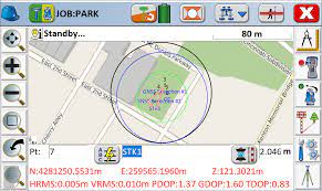
This software supports a wide range of devices and instruments used in RTK GPS and, with its simple and highly functional graphical interface, is one of the best tools for working with GPS data. GPS data is often accompanied by various errors. To address this issue, a technique known as RTK (Real-Time Kinematic Mapping) is used, which is a highly practical field method for determining relative positions and improving accuracy of satellite positioning systems.
SurvPC is a powerful and complete program for collecting and processing cartographic data. It supports various GPS/GNSS receivers and total stations, offering precise data collection, processing, and mapping capabilities.
Researchers choose Carlson SurvPC as their data collection software for good reasons. SurvCE (for Windows Mobile) and SurvPC (for Windows) combine advanced features, ease of use, and industry-leading functionalities with award-winning service and technical support.
SurvCE and SurvPC support emerging and popular RTK GPS systems, as well as traditional and robotic total stations, and provide the power of Carlson’s land coordinate geometry.