Geographic Calculator

Geographic Calculator is a reliable and comprehensive tool for converting and transferring geographic coordinates, as well as addressing geospatial/cartographic and geomatics issues. It is widely used by geoscientists, cartographers, and GIS professionals to simplify complex geospatial tasks with high accuracy.
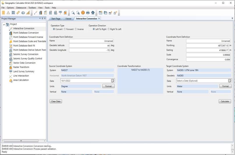
 

Geographic Calculator

Key Features of Geographic Calculator:

  1. Comprehensive Coordinate Conversion:
    • The software allows for high-precision conversion of geographic coordinates across various formats, including support for geodetic systems, and can easily handle multiple coordinate transformations.
  2. Wide File Format Support:
    • Geographic Calculator supports a wide range of file formats, including CTL files (Pearl software), SEG, SPS, and UKOOA, which are commonly used in geospatial and geophysical data handling.
  3. Geodetic Data Support:
    • The program has access to a large geodetic database, which includes global mapping parameters and conversion tools for precise coordinate transformation.
  4. Cloud Database Access:
    • Users can access an extensive cloud-based geodetic database, making it easier to work with up-to-date geospatial data and ensuring that users have the most accurate information at their fingertips.
  5. Customizable and Secure:
    • Geographic Calculator allows for customizing data access and editing permissions, ensuring data security and preventing unauthorized modifications.
  6. Interactive and User-Friendly Interface:
    • The software features a visual and intuitive interface that simplifies complex tasks, making it easy for both experts and beginners to navigate through the tools.
  7. Geophysical Tools:
    • It includes specialized tools for geophysical tasks, such as seismic conversion, and can calculate distances and other parameters relevant to geophysical studies.
  8. Project Management Tools:
    • Geographic Calculator provides project management tools to process geospatial data efficiently and helps streamline workflows, particularly in large-scale surveying and mapping projects.
  9. XML-Based Coordinate Library:
    • The program includes a comprehensive coordinate library based on XML, making it easier to manage and utilize various geospatial datasets.
  10. Integration with Global Mapper:
    • The software is fully compatible with Global Mapper, providing an easy way to export data for further processing in other mapping and GIS applications.
  11. Support for Geodetic Coordinate Systems:
    • It can work with a variety of geodetic coordinate systems, making it an essential tool for professionals in fields like cartography, photogrammetry, and geodesy.
  12. Multi-Platform Compatibility:
    • The software is optimized for Windows 10, with a user-friendly setup process, ensuring that it is ready for use on modern systems.
  13. Fast Data Access:
    • Users can quickly access recently used files and data, improving efficiency and reducing time spent navigating through large datasets.

Applications of Geographic Calculator:

  • Geospatial Analysis: Essential for professionals working in GIS, surveying, and mapping, as it provides high-accuracy coordinate conversions.
  • Geophysical Research: It is useful for seismic data analysis, as it supports conversion and distance calculation for geophysical studies.
  • Mapping and Cartography: Helps in transforming geographic data and generating accurate maps for planning, environmental monitoring, and construction projects.
  • Environmental and Land Use Planning: Can be used for precise land boundary mapping and environmental monitoring projects, ensuring accuracy in legal and regulatory frameworks.

Benefits:

  • High Precision: Geographic Calculator is known for its precise conversions, which are critical for tasks like topographic mapping and geophysical surveying.
  • Comprehensive Tools: With features like seismic conversion, geodetic transformations, and a vast library of coordinate systems, it’s a versatile tool for a variety of geospatial tasks.
  • Data Security: The ability to control access and editing permissions ensures that sensitive geospatial data is protected.
  • Seamless Integration: The program integrates well with other geospatial tools like Global Mapper, providing users with a complete workflow solution for handling and analyzing geospatial data.


Geographic Calculator

Geographic Calculator is a vital tool for anyone working with geographic data, offering essential tools for converting coordinates, managing projects, and processing geospatial data with precision.