Carlson Precision 3D is a 3D engineering software that combines the ease and enjoyment of a complete 3D environment with the precision and sophistication of advanced engineering tools. This software is more than just a 3D visualization tool.
It utilizes the latest technologies to allow users to seamlessly integrate data from various sources and create high-quality 3D surfaces (P3D Topo) and related results, including hydrology modeling (P3D Hydro).
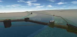
Your 3D designs are automatically drafted using CAD software, providing you with the necessary results while working in a faster and more intuitive 3D environment. This program generates highly accurate 3D models of terrain and waterways.
Precision 3D offers a wide range of tools and features to help engineers create precise and functional 3D models.
Carlson Precision 3D is a suitable program for creating and editing digital terrain models (DTM). A DTM is a 3D model of the Earth’s surface that stores X, Y, and Z coordinates of a specific land area.
This model considers all land features, including lakes, rooftops, boundaries, and other elevations.
By accounting for all land effects, DTMs provide a highly accurate representation of the Earth’s surface, and software like Carlson Precision 3D is designed for 3D visualization of these models.
A 3D model of this complexity provides engineers with excellent information. In addition to its standard formats, TIN and Grd, this software also supports two other popular data formats: LandXML and DXF.
One of the main features of this product is the ability to view and correct common errors in DTM models, which may occur in smaller programs. Surveyors, engineers, and contractors can rely on DTM’s final quality.
This product includes various editing tools such as surface merging, DTM vertex editing, edge and ridge editing, and more. Additionally, with multiple undo and redo operations, you can see changes being made progressively.